Africa's Anchor in
a Moving World
Gain operational clarity anywhere on Earth with a platform that fuses data from any sensor, automates the spatial intelligence cycle, and connects your systems to Nanga's AI-ready digital twin.
Vision Solutions
Built for Africa
From HD mapping to infrastructure monitoring, our AI-powered products are transforming transportation and mobility across the continent.
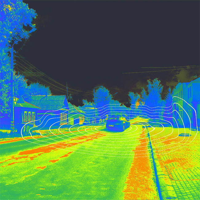
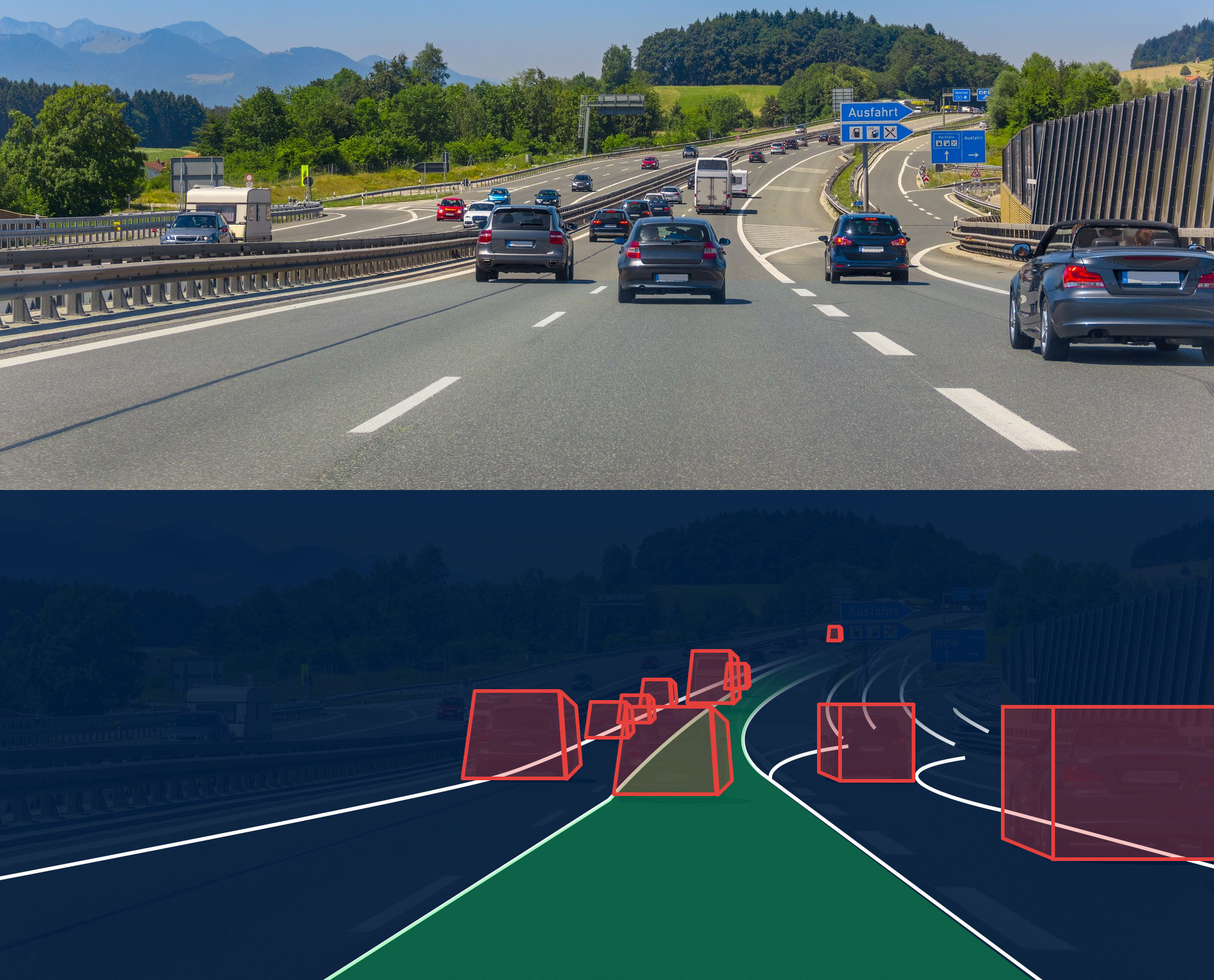
Nanga OptiSLAM
Core Localization & Mapping Engine
OptiSLAM is our core localization and mapping engine, designed to deliver centimetre-level accuracy across diverse environments. We fuse camera, LiDAR, GNSS, and inertial data into consistent HD maps and robust pose estimates suitable for navigation, ADAS, robotics, and large-scale mapping programs.
Other Products

Nanga Digital Twin Platform
Transforms mapping outputs into a living, analytics-ready virtual replica of infrastructure, assets, and environments. The platform ingests multi-modal sensor data, runs automated QA and processing, and produces spatially accurate models that support planning, monitoring, inspection, and decision workflows.

Nanga Real-Time Localization
A high-precision service delivering reliable, low-latency position estimates for vehicles, robots, and mobile platforms. It combines HD maps, GNSS corrections, and SLAM-based refinement to maintain accuracy even when signals degrade or environments change.
Nanga DataPack
Curated datasets for training, validating, and testing perception, mapping, and simulation systems. Each DataPack is produced through strict, multi-stage QA and domain-specific annotation protocols to ensure accuracy, consistency, and scalability.
The Nanga
Technology Stack
Deep-tech SLAM, multi-sensor fusion, and scalable data operations powering next-generation spatial intelligence.
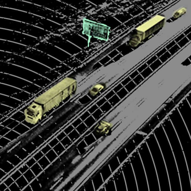
SLAM & Multi-Sensor Fusion Engine
OptiSLAMAt the heart of Nanga is OptiSLAM, our advanced localization engine. It fuses camera, LiDAR, GNSS, and IMU data into a stable, accurate representation of the environment.
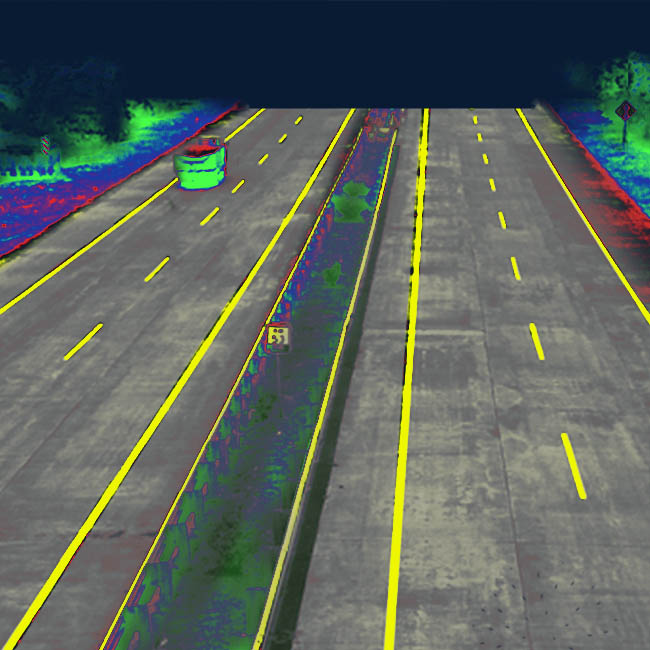
HD Map & Geospatial Processing
Production-Ready MapsNanga converts raw sensor streams into production-ready HD maps for navigation, simulation, and infrastructure intelligence.
Data Annotation & Quality Systems
Multi-Stage QAHigh-quality datasets are ensured through multi-stage QA, expert annotators, and domain-specific labeling.
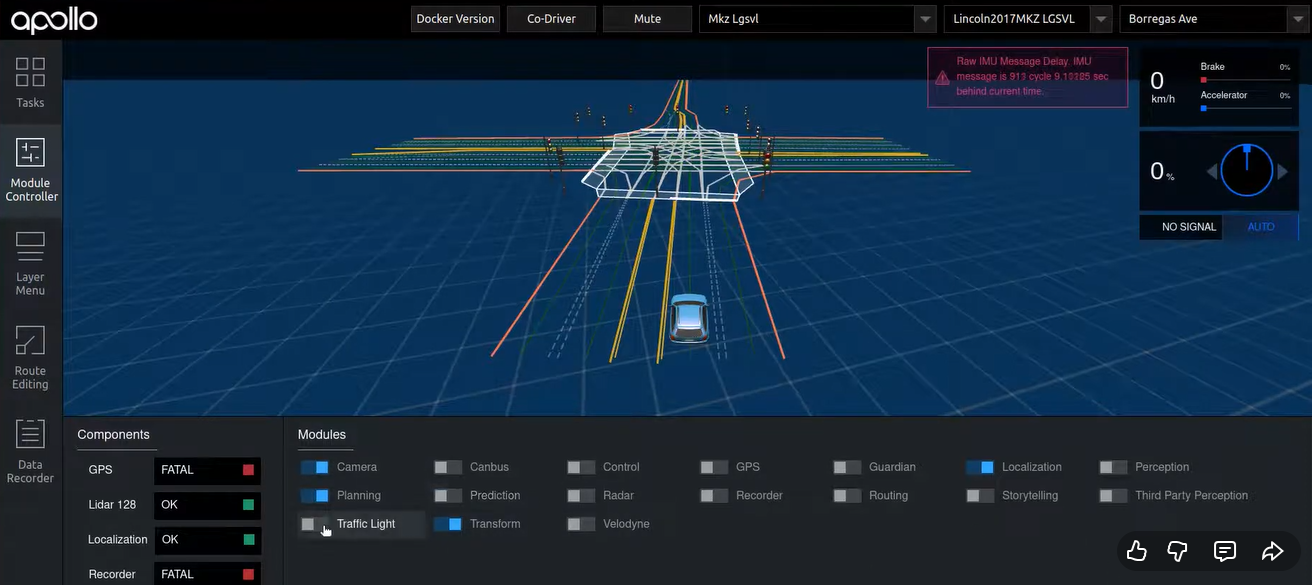
Real-Time Localization Framework
Precision PositioningOur localization layer blends HD maps, GNSS correction, and SLAM refinement for reliable real-time positioning.
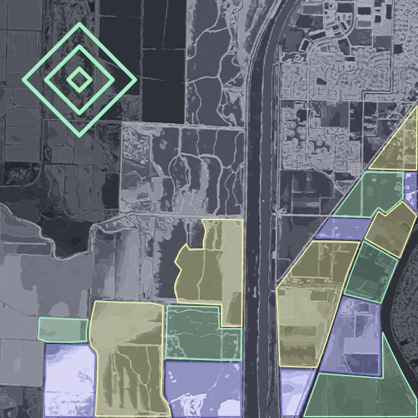
Spatial Intelligence & Digital Twin Engine
Interactive Digital TwinsTransform maps and sensor data into interactive digital twins for analysis, simulation, and asset management.
Deployment, Tooling & API Ecosystem
Production-ReadyOur ecosystem is built for production. Developer-friendly APIs, SDKs, and cloud/edge deployment options enable scalable operations and integration.
The Nanga Advantage
Capture
We deploy a multi-sensor fleet to collect rich 4D data, capturing the environment in unprecedented detail.
Process
Our proprietary Nanga OPTISLAM pipeline leverages deep tech and SLAM foundation models to process this data, drastically cutting the cost and time of mapping.
Model
We create global-standard HD maps and Digital Twins, tailored to the unique challenges of different industries.
Validate
Our outputs are rigorously tested and validated through simulation platforms like CARLA, ensuring production-ready reliability.
Professional Mapping Stack
While standard maps guide humans, HD maps provide the centimeter-accurate, feature-rich, and machine-readable reality model that autonomous systems require to see, think, and navigate. To bridge this capability gap across Africa, we've built a proprietary, hybrid mapping framework that dramatically reduces the cost of creating these mission-critical HD maps. Our production pipeline is engineered for reliability and global interoperability:
Industry-Standard Foundation
Our maps are built using globally recognized platforms and formats like Lanelet2, ensuring seamless compatibility with the world's leading autonomous driving systems.
Simulation-Validated
Every map is rigorously tested in simulation environments like CARLA to guarantee safety and performance before real-world deployment.
Production-Ready Output
We deliver maps in the AISAN format, the trusted standard for automotive-grade HD mapping used by major manufacturers worldwide.
We offer production-ready HD map that provides the foundational layer for Level 2-5 autonomous systems, smart infrastructure, and next-generation location services across Africa.
Mapping Africa,
One Country at a Time
Our HD mapping coverage spans major urban centers and highways across the continent, with continuous expansion into new regions.
Coverage Status
Digital Context for
Smarter Operations
Nanga delivers the digital context your operations need to thrive. We use industry-leading, cutting-edge reality capture to build AI-ready living models of the physical world, powering smarter decisions across diverse industries.
"We're Palantir for Geospatial technology."
Our Team
Nanga is powered by a deeply technical team led by founder Chris Nyamu, with founding engineers who bring over a decade of industry experience each. This seasoned team is united by a commitment to building robust, scalable geospatial infrastructure to deliver cutting-edge spatial intelligence solutions tailored to Africa's unique challenges and opportunities.
Capture
We deploy a multi-sensor fleet to collect rich 4D data, capturing the environment in unprecedented detail.
Process
Our proprietary Nanga OPTISLAM pipeline leverages deep tech and SLAM foundation models to process this data, drastically cutting the cost and time of mapping.
Model
We create global-standard HD maps and Digital Twins, tailored to the unique challenges of different industries.
Validate
Our outputs are rigorously tested and validated through simulation platforms like CARLA, ensuring production-ready reliability.
Our Services
Our solutions power next-generation mobility across multiple industries


Our Partners
Collaborating with leading organizations to advance road safety and infrastructure
Materials Testing and Research Division
Kenya
Quality & Safety
Ready to Transform
Your Mobility Solutions?
Contact our team to learn how Nanga can power your autonomous driving, fleet management, or infrastructure monitoring needs.
Contact Information
Reach out to discuss partnerships, request a demo, or learn more about our products.
Business Hours
Monday - Friday: 9:00 AM - 6:00 PM EAT
Weekend: By appointment only